More than a pin on a map
Show precinct boundaries, polling-place names and addresses, early voting locations and schedules, and district layers configured for your county.

FIND YOUR PRECINCT · BY DOLPH MAP
Your community. Your precincts.
One easy-to-use map.
Help voters find their precinct, polling place and districts with an interactive map built for your elections office.
Branded to your office. Ready for phones, tablets and desktops.
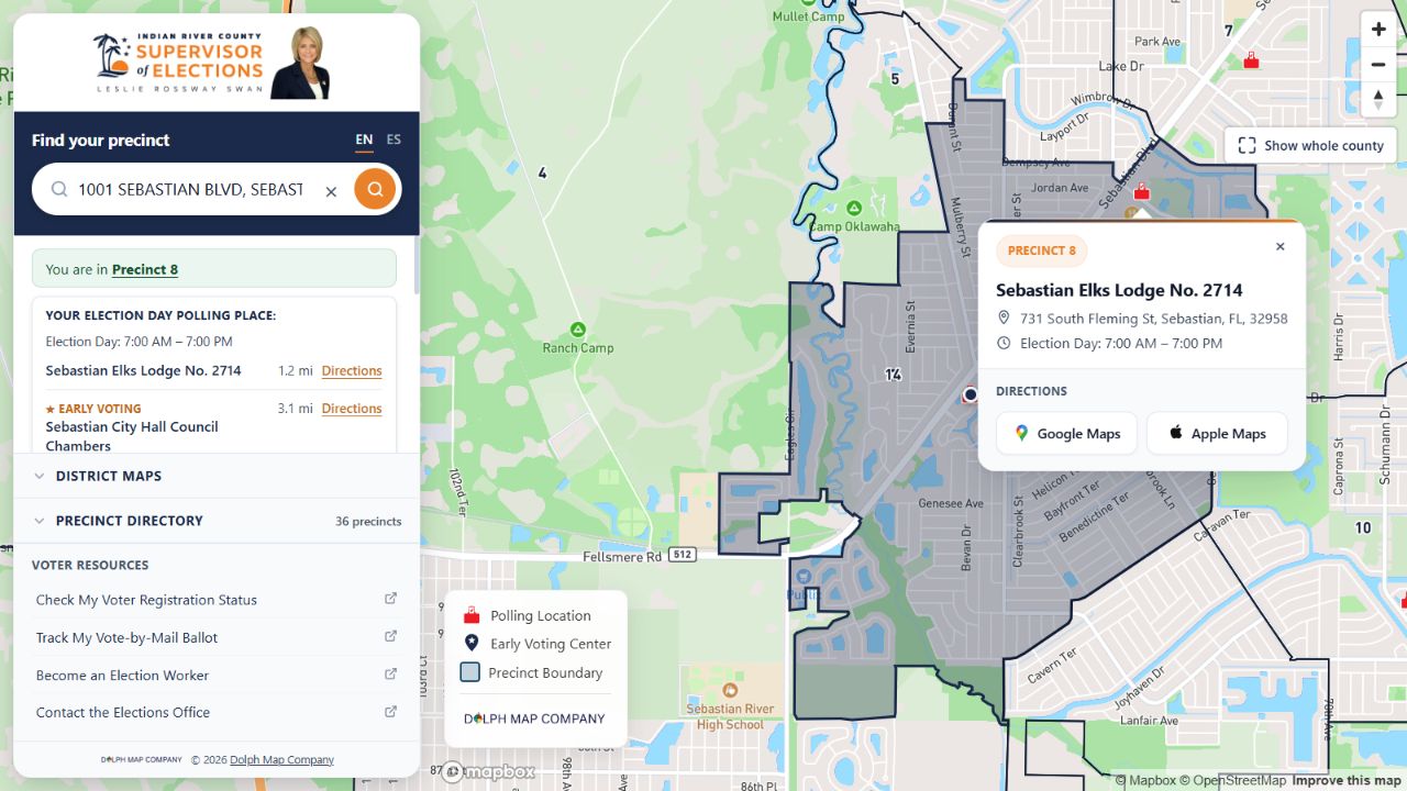
SIMPLE FOR VOTERS
Search a home address to locate it on the map.
View the precinct, polling place and available district information.
Open the polling location in Google Maps or Apple Maps.
TAKE A LOOK AROUND
Explore a real county map. Search an address, browse precincts or switch on a district layer.
Examples reflect each county’s configuration. This is a product demonstration; voters should confirm official voting information with their elections office.
BUILT AROUND YOUR OFFICE
Bring the details voters need into one map that feels like part of your office’s website.
Show precinct boundaries, polling-place names and addresses, early voting locations and schedules, and district layers configured for your county.
Your office’s logo and branding, an English/Spanish interface, and links to your official voter resources. Designed for phones, tablets and desktops.
Embed the map on your website or share a direct link in emails, social posts and QR codes. Send approved changes to Dolph Map for map updates.
FROM THE OFFICES USING IT

Amy Pennock · Supervisor of Elections
Our interactive map is a huge hit, voters really liked it and we had nothing but compliments on it.

Leslie Rossway Swan · Supervisor of Elections
The new features are totally awesome.
Comments from customer email correspondence about their interactive maps.
LET’S BUILD YOUR COUNTY’S MAP
Work directly with Dolph Map, from the first county example to the updates that keep it useful.
We’ll review your official precinct boundaries, polling places, voting schedules and the districts you want to show.
See your county’s branding and data together. Your office checks the details and tells us what needs adjusting.
Add the map to your website and outreach. Send us approved changes as your county’s information evolves.
Your office sends updated information and corrections to Dolph Map. We handle the map changes; administrative access remains with our team. We’ll discuss your update needs when planning your county’s map.
The map is an address-based reference tool that complements your official voter information services. It does not confirm registration or voting eligibility. Your map can link voters to your office’s official lookup and include your office’s guidance.
We configure the map around your county’s geography, voting model, branding and available data. Precincts, early voting, district layers and official resource links are reviewed with your office. Available details vary by county.
Contact Dolph Map for a quote based on your county and map requirements. One-year and multi-year licensing options are available.
YOUR COUNTY COULD BE NEXT
Tell us your county and what your office needs.
We’ll help you explore the right map.
Share a few details to get started. We’ll use them to respond to your request.
Prefer email? Contact Dolph Map.